Tuesday, July 22, 2008
Las Vegas to Phoenix
I've always liked the desert and when Margie suggested this trip as a family summer vacation, my ears perked. I am admittedly not a big fan of Vegas, but the overland trip to Phoenix via Hoover Dam and the Grand Canyon gave the trip some potential in my mind. The desert is a study in contrasts and as it turned out, so was this trip...
Monday, June 30, 2008
Over-nighter
Every so often I get the urge to go out in the woods and camp. Night before last I packed up and went out with my pack and headlamp, looking for a good place to string my hammock. It is interesting to bushwack up into the woods looking for a couple of trees spaced about 12 ft apart. Not that it is hard to find the trees, but, rather, looking at where you ended up in the morning under the light of day! The woods is just behind us and makes for a very convenient camping get-away when so inspired. We are located more-or-less in the great valley of Great Mills, MD, so that every noise seems t0 reverberate. Mostly vehicle traffic. It wasn't until about 2:00 AM when the bars closed that all was peaceful. The morning brings an on-slaught of bird calls. Just before dawn, just a few, but by sunrise, a complete bird symphony.
Saturday, June 14, 2008
Assateague Island Hike - April 2008
 Assateague Island has intrigued me since I was a youngster. Many trips to Ocean City, MD and I had never set foot on the island. The Assateague Island National Seashore was established in 1965 after prior development attempts succumbed to mother nature and indeed, there is little left of the planned commercial development that was growing prior to 1962. A nor'easter struck the island in 1962 wiping away the roads, power lines and structures that had been built. The developer bailed and, consequently, the public now has an unspoiled, 37 mile long barrier island that is an important wildlife refuge and provides an extremely unique hiking experience. I read about an AI hike in Leonard Adkins' excellent book,
 "50 Hikes in Maryland" (http://www.habitualhiker.com/index.htm) and became sort-of obsessed with this hike and began my planning. Leonard's hike took him from the northern Maryland side of the island to Tom's Cove on the Virginia end. Going solo, I decided to hike out from Tom's Cove, cross the state line into Maryland, camp overnight at the State Line Backcountry campsite, and return to Tom's Cove...about 25 miles round-trip.
I checked in at the Tom's Cove visitor center around 1200 on a tuesday. Being a weekday, there was only 1 other customer getting a fishing permit or something. The staff were very friendly and helpful, giving me suggestions on the hike. I just wanted to hike the beach, but there are a number of other options such as the service road that runs up the Virginia side of AI for about 9 miles. I decided to take the service road on the way back for change of scenery. The staff said they had not received any complaints of biting flying insects, which can be a problem during the warmer months. The visitor center is walking distance from the beach and there is a large, well maintained parking area right on the beach, so that's where I unloaded my pack and started out. My pack was a bit on the heavy side (38 lbs) due to the need for water (no fresh water source on this hike!). They recommend 1 gal per day, so I drank a liter of water on the drive in and carried 6 liters for the hike. 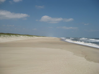

Setting out, the weather was decent (61 degF, mostly sunny and windy with gusts up to around 20 kts). There were maybe 10 people on the beach near the parking lot, shell hunting. As I headed north, I encountered my last human beings at around 1 mile. The pic to the right is pretty self explanatory. You can literally see for miles. Although the beach looks flat and feature challenged, it is actually a random rolling surface, particularly near the water. Hiking in sand with a backpack is fatiguing. Hiking up near the dunes, the beach is flatter, but the sand is dry and soft. Down near the wave line, the sand is firm but you are walking on a rolling slope. You pick your poison. I tried both and ended up preferring to stay down near the water line. This has it's perils though. About 3 miles into the hike, I was hugging the water line too close and was caught by a rogue wave. Soaked one of my boots. Not good, as I would find out later in the hike.
Not long after getting caught by the wave, I came upon a dead horseshoe crab. I flipped it over with my foot and next thing I knew, my ankles were being attacked by a swarm of LFBIs (low flying biting insects). Relying on the visitor center staffer's lack of concern over bugs, I didn't bother to put on any repellent. Bad move. Dancing around in the sand with a 38 lb pack and kicking at the bugs with my feet, I inventoried my options. Starting to take off my pack to get at the bottle of repellent, I decided to just try and outrun them. So I power walked about 100 yds and was clear of the LFBIs. Winded, off came the pack on came the deet.

The break gave me a good chance to really look around at the surroundings. At this point, I could see nothing man made either north or sound except for my pack (right). The dunes constantly change shape along the island reflecting the constant and random battering of ocean and weather. There is a constant glow as you look to horizon near the water line. This is the sun's illumination of sea spray kicked up by wave breakers over miles of beach ... a consistent feature over the entire hike. During my bug dance, I had managed to kick a small slug of sand into one of my boots. I could feel it, but it didn't seem to be posing a problem so left it alone (big mistake).

I herded these birds (pic to the right) for about 3 miles. They would fly ahead of me about 100 ft then feed. As I approached, they would squawk at me and fly a little further up the coast. Eventually, they became tired of my intrusion and flew back south. I was intrigued by a flock of small birds who seemed to be able to predict the wave's encroachment on the beach. When a wave receded, they would rush down to the very edge of the water and feed (I guess small crustaceans). Then when the next wave approached, they would rush back in perfect unison to the dry beach. The little birds seemed to know when not to press their luck...as if they knew when the wave motion was not predictable. I watched this for quite a while and tried to capture it on camera, but the birds were too small to see on the video.
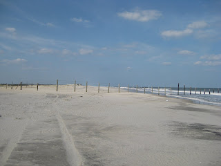

At long last, the VA/MD border. The fence doesn't look very imposing in the pic, but is pretty substantial in real life. The fence is primarily to keep the VA/MD pony herds separated and also, probably to keep wayward beach drivers from the MD side from traversing over to the VA side (no beach driving except for the southern most portion of the island in VA). I was not really excited about threading me and my pack through the barbed wire, but fortunately, the NPS (or someone) has installed a U-shaped passage through the fence so hikers just walk through. Apparently, the AI ponies cannot make sharp U-turns.

State Line campsite is a mile beyond the fence, just beyond the primary dune and is pretty austere. But the picnic table is a real luxury. Good planning by some NPS employee. This camp is about 12 miles removed from civilization, but sports a picnic table and porta-john! There is not a lot of room, though, due to the shrubs that are abundant in this area. You could probably fit 3 or 4 small tents in this site. Sitting at the picnic table, you can see the ocean and hear the waves breaking all night. The porta-john was clean and even had TP!
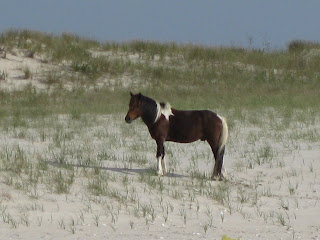 Next day, I spotted this lone pony on the MD side of AI about 200 ft from the beach. They call them ponies, but they are sized more like horses. This guy was pretty big. As I observed later in the hike, the mature males tend to graze off on their own, as this one was doing. The rest of the herd was probably just over the dune out of sight. I took quite of few pictures of this horse trying to catch him with his head up. Most of the time he was grazing and paid little attention to me. As I headed south on the beach and into VA, I met a pickup truck coming north. Two NPS employees out for the daily run and appeared to be stopping occasionally observing the wildlife and taking notes. A large portion of the VA side has signs requiring hikers to stay near the waterline due to sensitive bird habitats. You are required to stay water-side of these signs that are probably several hundred feet apart. For me, no problem since that's where I was walking anyway.
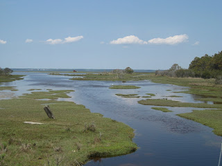
 Next day, I spotted this lone pony on the MD side of AI about 200 ft from the beach. They call them ponies, but they are sized more like horses. This guy was pretty big. As I observed later in the hike, the mature males tend to graze off on their own, as this one was doing. The rest of the herd was probably just over the dune out of sight. I took quite of few pictures of this horse trying to catch him with his head up. Most of the time he was grazing and paid little attention to me. As I headed south on the beach and into VA, I met a pickup truck coming north. Two NPS employees out for the daily run and appeared to be stopping occasionally observing the wildlife and taking notes. A large portion of the VA side has signs requiring hikers to stay near the waterline due to sensitive bird habitats. You are required to stay water-side of these signs that are probably several hundred feet apart. For me, no problem since that's where I was walking anyway.
As planned, I left the beach at about the 9 mile point from Tom's Cove to hike the service road. On some maps, this is called ragged point trail. This is not really a trail but a blue-stoned road. The pic on the right is looking west to Chincoteague Bay from the road. There is a white Egret near the center. The west side of the island at this point is wooded and is a sharp contrast to the sand dunes of the eastern side. The land is low and marshy. You pass the Wash Flats to the east which is essentially a sand marsh several miles in length. If you look back at the first pic in this post, it is the long white patch mid-way up the hike. I started to run into problems with mosquitoes along the way and had to double down on the insect repellent.
 I came across several herds of ponies grazing in the marsh. One herd was near the road and began to come up the bank to the road as I approached. Because there were two foals in the herd, I wasn't sure whether the animals would see me as a threat or not. Having worked on a dairy farm during my youth, I know a cow can be as aggressive as a bull if her calf is threatened. So I decided to take a break, have lunch and wait them out, hoping they would move on. Well...they didn't. Getting impatient and wanting to move on, I decided to just act like a horse and non-chalantly stroll through the gauntlet of ponies like I was looking for some good grass. It seemed to work as they barely even noticed me. In reality, these ponies have no natural predators so apparently have little fear of humans. Having cleared the ponies and getting tired of the road hiking, I took the first exit back to the beach! A few miles from the parking lot, I began to see some people. One couple were out shell hunting and waved to me. I waved back, but as I did, another rogue wave got me good. Undeterred and energized that my hike was almost done, I picked up the pace and power-hiked all the way back to the car, feeling pretty good about the whole experience.
Lessons Learned:
- Don't underestimate beach hiking. Even though the beach is relatively flat in comparison to mountain hiking, sand is extremely fatiguing.
- Windy conditions on the beach will blow sand into your hiking boots. Add some water from rogue waves and you will have blisters. I could barely walk for several days after the hike because of blisters. Wear gators. They will keep the sand out and probably most of the water if you get overcome by a wave. Take along an extra pair of socks.
- If you do get sand in you boots, get rid of it as soon as possible.
- If it is cool enough, wear long pants. They will help fend off the LFBIs. If you are just using insect repellent, make sure you put it on under your socks. The LFBIs can bite through socks.
Have a good one!!!
Subscribe to:
Posts (Atom)
